
Old
Testament's Catastrophism
Christian
Science & Archeology
The Flood of "Noah" -
Chapter 1
by Donald W. Patten
| The Flood of Noah - Chapter 1 - W. Patten È Click on chosen subject! È |
|
|
It looks like a shipwreck! |
|
| Our Excursion; June 1990 |
|
| Our Gang | |
| The Date | |
| The Descending Climb | |
| The Metal Detection Equipment | |
| Indentifying the "Problem"! | |
| The Problem Clarifies (in Part) | |
| Two - Gravity Event! | |
| Floating Uphill Versus Downhill | |
| About the author Donald W. Patten & his scientifically written book! | |
| The flood of Noah | |
| Biblical Scientifically studies are always freely available for everyone! | |
Flood of
Noah
Chapter 1...
Donald W.
Patten ©
And the
Ark
rested in the seventh month, on the seventeenth
day of the month, upon the mountains (or
highlands) of Ararat. (Genesis
8:4)
In
August, 1883, a small volcanic island in
Indonesia named Krakatoa erupted. The eruption
created a 'monstrous' cavity in the cone, into
which the walls of the belaching volcano
collapsed. That collapse of volcano walls
produced a series of massive ocean waves
in the Java Sea. Those tidal waves uplifted
small boats, anchored at dock side, and swept
some of them inland up to 2 miles. The boats
rode waves cresting at 50 feet high.
This is what the 19th century called "a
catastrophe."
The waves were not "tidal" in the sense
that they were caused by a passing celestial
body. Lacking an appropriate word in English,
the Japanese word "tsunami" was adopted.
In
contrast,
Noah's
Ark was swept upward over
6,000 feet. It was swept onward over
550 miles.
These pair of distances, to a geographer, is
what is so intriguing about finding the remains
of this vessel. It is found in the most unlikely
of places, the highlands of semi-arid Inner
Asia. How this vessel survived the rapid and
stressful journey is similarly intriguing to a
marine engineer.
Apparently its size and buoyancy helped.
So did careful planning, quality carpentry, and
extraordinary preparation at its graving dock,
the construction site.
David Fasold claimed to have identified
subsurface iron in
discrete
locations, or spots within a boat-shaped
formation. The place is 5 miles southeast of
Dogbayazit, Turkey. The iron
locations or spots, over where the frequency
generator located iron, were red flagged.
The red flags assumed patterns of lines.
He then measured the distances of the horizontal
lines. The longest dimension, from bow to stern,
was 515
feet.
The
Genesis account of
Noah's
Flood says that the dimensions is that the
Ark
was shaped like a long box, 300 cubits long, 50
cubits wide and 30 cubits high. Fasold, a
seaman, claimed that a box-shaped
Ark
with a length/depth ratio of 10:1 would capsize,
like a rolling log.
Moreover he claimed that an
Ark
built of any kind of wood (including
"gopher-wood") could not survive the stresses of
wave crests and troughs. Only vessels
manufactured of aluminum or steel can handle
such stresses. His analysis, on the surface,
seemed reasonable.
In May l989, Fasold was invited to come to Seattle for a lecture. We (Donald Patten and Windsor) were giving a series of seven lectures on Earth history at a Baptist church, and Fasold was invited to give one of those lectures. He did this and he presented his sketches, his graphic printouts and his story. He stayed three days, and was questioned at length. Grilled might be a better description!
 From this 'grilling', it was determined
first that Fasold was a "straight arrow," a
thoroughly honest person.
Secondly it was determined that his
background as a seaman (10 years in the merchant
marine, part of which he served as a ships
officer) and as a ship salver (15 years in the
Caribbean operating out of Key West) compensated
for his lack of academic achievements in this
marine matter.
In seafaring issues, he is definitely "an
old salt."
From this 'grilling', it was determined
first that Fasold was a "straight arrow," a
thoroughly honest person.
Secondly it was determined that his
background as a seaman (10 years in the merchant
marine, part of which he served as a ships
officer) and as a ship salver (15 years in the
Caribbean operating out of Key West) compensated
for his lack of academic achievements in this
marine matter.
In seafaring issues, he is definitely "an
old salt."
In early 1990, Fasold was planning on
taking three tour groups to the alleged
Ark
Site. We
were two of eleven who signed up for the first
tour, scheduled for mid June.
The other two tours, scheduled for August
and September l990, never occurred because of
the Iraq-Kuwait crisis. The Turkish military
commandeered all aircraft including civilian
flights. We considered ourselves fortunate to
have been scheduled for the first tour, when
armies were still at peace.
David Fasold published a book in l989, The
Ark
of
Noah.
He claimed to have located the remains of
Noah's
Ark!
(His book was published by Wynwood Press, (hard
cover, in two printings, and was a l989 best
seller. In l990 it was published in Europe in
English under a similar title. The book came out
as a paperback in 1991, published by
Knightsbridge Publishers. This version also sold
out quickly).
Our tour
group was ten in number.
One, Marvin Luckerman, editor of
Catastrophism and Ancient History, a semi-annual
periodical, had a passport expiration problem
and thus "missed the boat."
Our group of ten included Fasold,
ourselves, Erma Windsor (Snohomish, Wn.), Bill
Taylor (amateur archaeologist, Albuquerque),
Drs. Melvin and Phil Carkl (pathologist and
dentist, Gainesville, Fla.), Gil Smith
(evangelist, Fredericksburg Texas,
Andre Iseli and Carlin Lehr, both of
Sandy, Oregon.
Iseli is owner and Lehr is supervisor of
irrigation at the Iseli Nursery.
Their interest was botanical, to bring
back a sample of the rare amomum plant which
grows only near the
Ark
Site.
Amomum, related to the iris, is reputed by the
Kurds to have life lengthening powers.
Our gang congregated at Istanbul, and
proceeded by air to Ankara and then to Van, and
on by bus to Dogubayazit.
Dogubayazit is the easternmost town of
Eastern Turkey.
Dogubayazit, the local hub, is located 7
miles from the Fasold Formation, the Fasold
Ark
Site, and is l2 miles from the site of the
Anchor Stones.
Also, Dogubayazit is
5 miles north of the Iranian border and
is only l2 miles southwest of the famed Mt.
Ararat.
Soviet Armenia is 30 miles distant, to
the northeast.
Figure 1 illustrates where Dogubayazit
and the Fasold Formation are in Eastern Turkey,
also known as Eastern Anatolia.
Figure 2 illustrates how far this
Ark Site is from a major ocean, such as the Indian Ocean to the
south.
We were indeed in the highland country of
remote Inner Asia.
(Figures
1
&
2)
Our gang also included Dilaver, a Turkish
guide from Erzerum, whom Fasold had used in each
of his 6 or 7 past trips to Eastern Turkey.
Dilaver was very helpful in a variety of ways,
especially in interacting with the locals, the
Kurds at the
Ark
Site, in Dogubayazit, at the Anchor Site (Kazan)
and in the city of Van.
As
it happened, we motored from Van to Dogubayazit
on Saturday, June 20, a journey of about 100
miles, across the relatively bleak terrain, up
to 8,500 feet elevation,
of Eastern Turkey, where the leading industries
are making rugs and herding of goats and sheep.
Herds of goats and/or sheep always means
no forests or trees.
(They graze on tender sapling shoots)
The elevation ranged between 5,500 feet
and 9,000.
The landscape was reminiscent of Utah and
Western Colorado.
On the morning of June 2l, the longest
day of the year, we photographed shimmering Mt.
Ararat at sunrise from our
third floor lanai (at the Isfahan,
formerly Ararat Hotel).
The sunrise scene brought to mind the
dawn of a new day, and of new ideas, including
the idea of David Fasold as to the location of
the remains of
Noah's Ark. How solid would be his
supporting claims for scientific and cultural
evidence?
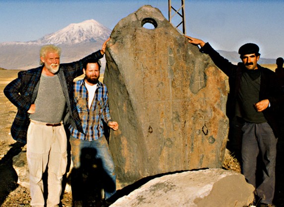
Illustration source from Anchor Stone
International (Persons are not the
same as in this story!)
At
approximately 8:30 am, we visited the site of
the "Chip Stone", near the village of Kazan.
(More
about this later in this chapter).
About 9:30, we motored 2 or 3 miles to
visit the site of the
11 anchor stones, at the
edge of
Kazan.
These unique stones appeared like huge,
oversized anchor stones from ancient Phoenician
vessels.
They were inspected, measured and noted
meticulously.
The elevation was measured by altimeter.
The height, width and thickness of the
anchor
stones were measured by a metal tape
measure, as were the various diameters of the
holes at their tops. Their weight was estimated
by using the standard engineering table weight
for average rock, which was multiplied by the
volume.
The roundness of the holes, and the curvature of
the hole chutes were examined with a magnifying
glass, calipers and a ruler.
A compass and a recording tablet were
among other items of hardware employed.
(Our intrepid engineer, examining the minute
details, was the very picture of Sherlock Holmes
except for the deer hunter cap.)
At noon time, at about the minute as well
as the day of the summer solstice, our bus
arrived at the Visitor's Center, some 7 miles
southeast of Dogubayazit and 2 miles north of
the Iranian border.
This was built in the summer of 1989.
The Turkish Department of Antiquities has
concluded and recognized the Fasold
Ark
Site as a national park and an ancient
historical site.
Thus, a 3,000 sq. ft. building,
overlooking the site, was constructed and a
two-lane gravel road was built to get visitors
and researchers there. The Turkish name for this
location is "Nu'hun
Gemisi," (Noah's
Vessel).
The site appears on Turkish government
maps published since 1990.
The Visitor's Center is perhaps 1,000
feet distant, horizontally, to the west, from
the alleged
Ark
Site. And it is perhaps 200 feet higher.
We lunched at the Visitor's Center and
observed from afar the Fasold Formation, the
alleged
Ark Site. As we viewed it, we
bore in mind the unfounded claims of various
Ark
hunters of Mt. Ararat
persuasion, claims long on talk and totally
lacking in evidence!
Over the last 15 or 20 years, the Mt.
Ararat
Ark 'hunters', without a scrap of honest evidence, have asserted
that the remains of the
Ark
must lie somewhere high in the zone of flowing
glaciers, over 14,000 feet above sea level.
Keeping such recent history in mind, we
told ourselves,
"Don and Sam, keep your guards up."
Missourians, traditionally, have to be
shown.
Kansans and Montanans (which we are) also have
to be shown.
From a distance of 1,000 feet, we viewed
'Fasold's'
Ark Formation for some 45 minutes, lunches in hand, and asked
ourselves, "Is this really
the
Ark
Site." Our momentary answer was, "We are
from the West, and like Missourians, we have to
be shown.
From what we saw at that point in time, we felt
perhaps it is and perhaps it isn't.
We were familiar with Fasold's book,
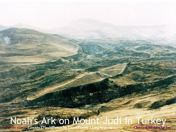
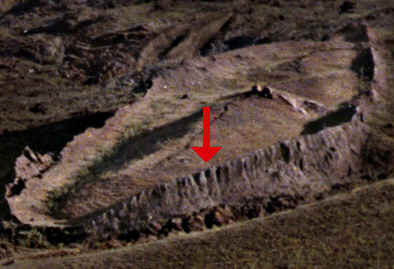
Permission was needed to go down upon the Ark Site itself, and our gang had permission through our guide, David Fasold. We began the slow and steep descent, at an angle of between 25 to 30 degrees, down and easterly from the Visitor's Center to an arroyo. Youth was in the lead. The arroyo was crossed with a some difficulty; criss-crossing cracks occurred there from 1 to 2 feet wide and 6 to 10 feet deep lacing the arroyo. Footing was hazardous, especially for the one lady in our group (Erma Windsor). After crossing the arroyo, there was a short climb, horizontally, of perhaps 250 feet. We were at the lower end, the bow end of Fasold's alleged Ark Site!
The
Ark
Formation itself is uplifted 10 to 15 feet,
sharply above the adjacent hillside slopes.
The edges of the formation are abrupt,
with 70 to 80 degree angled drop offs.
The walls, forming the edge of the
formation completely around it, are 10 to 15
feet high.
In 1985, Fasold was the first to measure
and record the length and the width of the
formation, which he measured
down to the inch, carefully.
The length of the formation was 5l5 feet, 9
inches which is 300 cubits.
The width at maximum beam was measured at
138 feet,
4 inches feet which is 80 cubits. This
assumes the Babylonian cubit, 20.6 inches. Thus,
the 300-cubit length was, but the 80-cubit width
was not in conformity with the
Genesis
record, IF maximum beam is what the
Genesis
account
Genesis
refers to.
We found two log ends high up on the
stern end, on sides opposite each other.
They were in a state of
semi-prettification. We observed what looked
like a series of knobs on both sides of the bow,
spaced regularly, about every 8 feet. They
appeared to be vestiges of
ancient rail constructs.
After about 1 hour of our gang touring
the site generally, Fasold unpacked the various
pieces of equipment, which he assembled into a
metal detector.
He had brought this heavy equipment via
air from California at some expense and
inconvenience. Packing the equipment from the
Visitor's Center down to the
Ark
Site and back was done by Kurdish locals under
the supervision of Dilaver.
From his book, The
Ark
of
Noah,
we read of Fasold's theory that there had been
an iron age before the Flood. (See
Genesis
4:22
about Tubal-Cain's foundry.)
Fasold activated the metal detector,
using his body as a conductor. It had two metal
rods about 5 feet long on either side. It also
had two beryllium rods, which shifted to a
crossing position each time iron metal was
detected. Also, as iron was detected below
Fasold's body, the detector beeped, while the
beryllium rods crossed.
Fasold then placed
red rods, or flags
at each spot where he stood as the metal
detector indicated iron there under. The
red flags
were positioned 18 to 21 inches apart over the
iron. The
red flags
began to merge into lines.
Other lines began to merge into parallel
lines, forming a skeleton of an ancient
artifact.
The lines that
developed were parallel, like longitude
lines, to the bow-to-stern axis.
The lines seem to be remnants of ancient
deteriorated wooden beam or bulkhead lines.
In addition, at two locations, which
Fasold considered the back end of the "Moon
Pool," to the aft but near center line, the
metal detector just sang.
In fact, the metal detector sang from
1000 feet at the Visitor's Center when pointed
at the formation.
It appears that at aft end of the Moon
Pool, there had been some heavy iron equipment,
used in association with the ropes and anchor
stones.
They may be rusted, deteriorated capstans or
Spanish windlasses.
Perhaps they were from equipment used to
reel in the ropes attached to the Anchor Stones,
using cattle power or possibly horse power.
Earlier that day, at the Anchor Stones site, we had seen large stones, flat on two sides, with rounded holes with radii of curvature, at the top. Those holes varied in diameter from 3 to 4.5 inches, with the larger holes always being in the larger, heavier stones. The radius of the hole varied with the square of the estimated weight of the anchor stone. Interestingly, one of the stones had a Babylonian zigurat carved on one side. It appears that the pre-flood civilization had a sophisticated rope-making industry!
In addition, a few iron pieces have been found which, when assayed, indicate an alloy with manganese. (No iron spots were found outside the formation). Such an alloy suggests electrolysis was known in the pre-flood civilization! We must not assume they were knuckle-dragging Neanderthals, as some anthropologists have suggested!
NOTE: (This part is added!) The human race yet retained much of its early vigor. But a few generations had passed since Adam had access to the tree which was to prolong life; and man's existence was still measured by centuries! Had that long-lived people, with their rare powers to plan and execute, devoted themselves to the service of G-D, they would have made their Creator's name a praise in the earth, and would have answered the purpose for which He gave them life. But they failed to do this. The people were granted the opportunity of reaching a high standard of moral and intellectual attainment.They possessed great physical and mental strength, and their advantages for acquiring both religious and scientific knowledge were unrivaled. It is a mistake to suppose that because they lived to a great age their minds matured late; their mental powers were early developed, and those who cherished the fear of God and lived in harmony with His will continued to increase in knowledge and wisdom throughout their life. Could illustrious scholars of our time be placed in contrast with men of the same age who lived before the Flood, they would appear as greatly inferior in mental as in physical strength. As the years of man have decreased, and his physical strength has diminished, so his mental capacities have lessened. There are men who now apply themselves to study during a period of from twenty to fifty years, and the world is filled with admiration of their attainments. But how limited are these acquirements in comparison with those of men whose mental and physical powers were developing for centuries! It is true that the people of modern times have the benefit of the attainments of their predecessors. The men of masterly minds, who planned and studied and wrote, have left their work for those who follow. But even in this respect, and so far as merely human knowledge is concerned, how much greater the advantages of the men of that olden time {Pre-flood)! They had among them for hundreds of years him who was formed in God's image, whom the Creator Himself pronounced "good"--the man whom God had instructed in all the wisdom pertaining to the material world!
We are serious readers of the Book of Job, and especially of the part, chapters 38-41. Here, after several excruciating, stressful weeks, the beleaguered Job had two revelations from the Lord of the themes of creation in a rapid sequence. Job's response after the first revelation was one of abject humility. Job's response after the second revelation was, "I have heard of thee by the hearing of the ear: but now mine eye seeth thee." (Job 42:5) Job was overwhelmed with awe!
So it was that we had heard from Fasold,
lecturing in person, and had read his book about
the iron spots, numbering an estimated 5,400
at the
Ark
Site. We
had read about the tear-drop shape, and the
Biblical dimensions of the artifact.
But now we had seen the iron spots as
they were being located by sophisticated
equipment once again.
Like Job, we were overwhelmed. Since no
iron spots (none at all) were found outside of
the
Ark-shaped
formation, our conclusion, beyond any shadow of
any doubt, was that this formation contained the
remains of a shipwreck, a very ancient one
indeed.
The location was at one of the most
unlikely of places on
Earth, it was true, 6,300 feet above sea level, and 2,000 miles from
the nearest ocean.
Nevertheless, there it was, beneath our
feet, for our eyes to fathom and for our minds
to feast upon.
We were treading ground where
Noah
once trod. However, the evidence we found
indicates only that it was a man-made artifact,
with
Genesis-like
dimensions.
There was no name-plate saying, "Mfg. by
M.
Noah
& Sons."
We shall identify the problem of how the
Ark
got there by first
assessing where it ended up, and
secondly, from
where the
Ark
was built, its graving dock.
This will provide the horizontal distance
it floated horizontally, in miles.
Simultaneously, this will provide a most
interesting calculation, the vertical distance
the
Ark
was uplifted, the elevation differential.
Thirdly, we
will discover in what direction it was moved
from graving dock to wreck site.
(1)
THE END OF THE JOURNEY.
The remains of the an huge vessel indeed
are found!
As mentioned above, we did not find a nameplate,
saying in English or in Akkadian or in Sumerian
cuneiform, "Manufactured by M.
Noah
& Sons."
The location is 7 miles southeast of
Dogubayazit.
And its location is also l8 miles
distant, and is but one degree lacking of being
due south of Mt. Ararat.
This location is at latitude 39
deg. 26 min. N., and at
longitude 44 deg. 15 min. E. by modern
geographical coordinates.
This location identifies where some
ancient vessel, 300 cubits long, finally rested
and subsequently decayed.
For working purposes, let us assume that
the decayed vessel indeed was
Noah's Ark. (If it wasn't, it
was someone else's vessel!)
(2)
THE BEGINNING OF THE
JOURNEY.
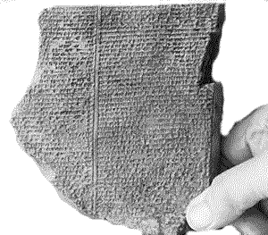
In the last 125 years, there have been
found no less than nine
flood accounts on ancient cuneiform, on
clay tablets with a
wedge-type writing.
Three are Sumerian.
Three are in Old Babylonian (Akkadian)
and three flood accounts are in Assyrian.
Several flood stories are in fragmentary
form. They
appear to date backward from 1000 B.C.E.
Possibly some are as old as 2000 B.C.E.
And almost certainly, they are copies
(exact or inexact) of even older cuneiform
accounts.
The most complete of these cuneiform flood stories is in Assyrian, The Epic of Gilgamesh In it, Gilgamesh, a post flood city potentate or lord, was interested in the idea of, and gaining eternal life. It was suggested he look up Noah, then still alive, living at or near the Mediterranean coast. He found, and interviewed Noah. Noah related the flood experience which the intrepid Gilgamesh reported in the first person singular!
The
pronouns he used when rendering
Noah's
story were
Noah
(Utnapishtim) saying
"I", "my" and "mine."
In the Epic of Gilgamesh, we learn that
the post-flood settlers of the lower
Tigris-Euphrates Valley came upon the silted
over remains of
pre-flood
cities.
They dug them out for memorabilia and for tools.
Then, time after time, they built new,
post flood cities over the older,
pre-flood
silted over urban sites.
And the new post-flood cities were given
their
pre-flood
city names.
This happens more than a half dozen
times. One
of these sites is/was Shuruppak, both a
pre-flood
city and a post-flood city.
In the Epic of Gilgamesh, one finds it
recorded that
Noah
was familiar with several
pre-flood
cities such as Shuruppak, Nippur and Uruk (or
Erech, the modern Warka).
In this account, on Tablet XI,
line 23, we read about
Noah:
Reed hut, hearken!
Wall, consider
Man of
Shuruppak, son of Ubara-Tutu! Tear down (thy)
house, build a ship! Abandon (thy) possessions,
seek (to save) life!
The temptation exists to discuss various
issues in this citation that are tangent to the
moment.
What we wish to point out here is that
Noah
was familiar with the
pre-flood
city of Shuruppak, indeed seems to have been a a
citizen of it.
Once the post flood city of Shuruppak is
located, one locates simultaneously the
pre-flood city of Shuruppak.
On this basis, we postulate
the graving dock for the
construction of
Noah's
Ark was within 15 miles of Shuruppak.
The post-flood ruins of Shuruppak are
found in Southern Iraq at approximately 31 deg.
45 min. N. latitude and at 45 deg. 35 min. E.
longitude.
Thus, Shurippak, near where the
Ark originally was built, is about 543 miles distant from
the
Ark
Site near Dogubayazit, at the village of
Uzengili, formerly Nisir.
(We assume the
Ark
was floated there by massive tides on a curled
line, not a straight one.)
The
Ark
was floated essentially north by north by
northwest (by modern spin pole reckoning).
 This distance, about 543 miles as the
crow flies, was probably closer to 580 miles, or
even 590 miles in its actual route. (See Chapter VI.)
Its net change was 7.81
degrees of latitude to the north and 1.2
degrees longitude to the west.
Such was the horizontal distance of
Noah's
"pleasant nautical tour."
This distance, about 543 miles as the
crow flies, was probably closer to 580 miles, or
even 590 miles in its actual route. (See Chapter VI.)
Its net change was 7.81
degrees of latitude to the north and 1.2
degrees longitude to the west.
Such was the horizontal distance of
Noah's
"pleasant nautical tour."
Shuruppak is by our reckoning about l50 feet above modern sea level. The Fasold Formation (the apparent Ark Site) is 6,300 feet above! (We allow that pre-flood sea level may have been was some 400 feet lower than modern, post-flood sea level, but that changes nothing.) The elevation of the Nisir/Uzengili bench, where the Ark originally was moored, before it slipped down slope, is about 6,500 FEET ABOVE MODERN SEA LEVEL! Thus, we assess (along with some 600 so miles of horizontal touring) some 6,350 feet of vertical touring! It was a most interesting tour indeed!
The direction the
Ark
moved can only be related to the modern cardinal
directions. We shall see
(in Chapter X)
that there were several spin axis location
shifts, including a massive one during
Noah's
Flood.) By
modern reckoning, based on the above
coordinates, the
Ark
moved due north by 5.6 degrees west.
Knowing this, the flood waters, however
high, came from the opposite direction, south by
5 or 6 degrees east.
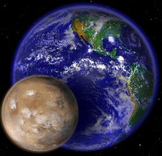
This points directly to the Indian Ocean
as the source of the tides for
Noah's
Flood. The Indian Ocean is due south of Asia,
averages 12,500 ft. deep, covers 28,350,000 sq.
miles, and has a volume of about 66 million
cubic miles of water.
In the
Genesis
account,
Genesis
7:11,
note the nautical detail: In the
six hundredth year of
Noah's
life,
in the second month, the seventeenth day of the
month, the same day were
ALL THE
FOUNTAINS OF THE GREAT DEEP BROKEN UP...
This phrase describes, to Chaldeans, their great
ocean to the south, what we today know as the
Indian Ocean.
The
Problem
Clarifies
(in Part)
There is the journey of the
Ark
of between 550 to 600 miles horizontally for
which to account.
An extreme tidal wave today might move a
small boat a mile inland, and 30 or 40 feet
above high tide.
These flood waters had height approaching
5,000 feet plus sub-crustal expansion.
They had breadth of 2,000 miles, and
more. This
implies high velocity, high volume water!
In August, 1883, a small volcanic island,
Krakatoa, erupted massively.
It created a monstrous cavity, into which
the walls of the belching volcano soon
collapsed.
In the Java Sea, that sudden collapse of
volcano walls produced a series of massive tidal
waves.
Those tidal waves uplifted small boats, anchored
at dock side, and swept them inland up to 2
miles, on tidal waves that crested at 50 feet
high.
That is what the 19th century called "a
catastrophe."
(In ancient times it wouldn't have been
worth mentioning.)
 By
contrast,
Noah's Ark was swept inland and upward over 6,350 feet.
Moreover it was swept onward over
550 miles.
To a geographer, this is what is so
intriguing about finding the remains of a vessel
in the most unlikely of places, the highlands of
Inner Asia (Eastern Turkey).
Moreover, to a marine engineer, how the
vessel survived the obviously stressful journey
is similarly rather intriguing.
Apparently is remarkable size helped.
And estimating the velocity of those waters is a
challenge.
From certain conditions in the geology of India
(see Chapter IV),
it is apparent that those flood waters had
velocities in some places approaching 300 mph.,
twice as fast as atmospheric movement during
typhoons or hurricanes.
By
contrast,
Noah's Ark was swept inland and upward over 6,350 feet.
Moreover it was swept onward over
550 miles.
To a geographer, this is what is so
intriguing about finding the remains of a vessel
in the most unlikely of places, the highlands of
Inner Asia (Eastern Turkey).
Moreover, to a marine engineer, how the
vessel survived the obviously stressful journey
is similarly rather intriguing.
Apparently is remarkable size helped.
And estimating the velocity of those waters is a
challenge.
From certain conditions in the geology of India
(see Chapter IV),
it is apparent that those flood waters had
velocities in some places approaching 300 mph.,
twice as fast as atmospheric movement during
typhoons or hurricanes.
TIP
# 1.
The
Genesis account recalls the onset day of
Noah's Flood in the following way:
In the
six hundredth year of
Noah's
life, in the second month, the seventeenth day
were all the fountains of the great deep broken
up, and the windows of heaven were opened.
Genesis. 7:11
What
was "the fountains of the great deep?" It
was the largest body of water then known to
inhabitants of the Middle East, the Indian
Ocean! Today, the Indian Ocean, covering
28,000,000 sq. miles, reaches from India and the
Tropic of Cancer to the Antarctic Circle on one
hand, 25% of the circumference of our planet.
And it is a lonely ocean, almost bereft of tiny
islands, stretching from Africa to Australia on
the other axis. This is 75 to 80 degrees of
longitude, another 5,500 miles. As previously
mentioned, the Indian Ocean's average depth is
12,500 feet deep, and it contains 66,000,000
cubic miles of water.
This body of water, we suggest, was
source of the tides of
Noah's
flood, "the great deep," as was
compared to lesser ancient bodies of water.
TIP
# 2.
The same
verse of
Genesis indicates that the "great deep"
was broken up.
The change would have to be sudden, since
water flows back to sea level rapidly.
Could this description mean either tides
or tidal waves?
Tidal waves are results of subterranean
Earthquakes
and volcanoes.
Tide, on the other hand, are caused
by a second astronomical body, a second
gravity suddenly entering the scene!
 The Epic of Gilgamesh provides a solid
clue as to what caused
Noah's
Flood.
It says the flood was caused by Enlil.
Enlil was one of several 'Sumerian cosmic
deities', one among the company of Ea, Anu,
Ninurta and Inanna.
These latter four deities were the
Earth,
Jupiter, Saturn and Venus respectively. Enlil,
the ravaging celestial deity, was the planet
Mars! On several occasions in
the Epic of Gilgamesh, Enlil is pointed or
singled out as the deluge's cause.
For example, lines 166-171 of
Tables XI read: "Let
the gods come near to the offering; But Enlil
shall not come near to the offering; Because
without reflection he brought on the deluge; And
consigned my people to destruction! As soon as
Enlil arrived and saw the ship, Enlil was
wroth!"
The Epic of Gilgamesh provides a solid
clue as to what caused
Noah's
Flood.
It says the flood was caused by Enlil.
Enlil was one of several 'Sumerian cosmic
deities', one among the company of Ea, Anu,
Ninurta and Inanna.
These latter four deities were the
Earth,
Jupiter, Saturn and Venus respectively. Enlil,
the ravaging celestial deity, was the planet
Mars! On several occasions in
the Epic of Gilgamesh, Enlil is pointed or
singled out as the deluge's cause.
For example, lines 166-171 of
Tables XI read: "Let
the gods come near to the offering; But Enlil
shall not come near to the offering; Because
without reflection he brought on the deluge; And
consigned my people to destruction! As soon as
Enlil arrived and saw the ship, Enlil was
wroth!"
And so it was with the celestial family
squabble in the heavens. According to
Sumerian sources,
the cause was
Enlil
(Mars). According to
Chaldean sources it
was
Bel (Mars). According to Assyrian cuneiform
sources, it was
Nergal-Mars,
sometimes translated as "Irregal".
Mars was the
culprit,
not Venus... Enlil,
not Inanna... Bel, not Ashtoreth.
In the Krakatau experience, the original
cause of the tidal wave
was the creation of the cavity. Then,
DUE TO
GRAVITY, the walls of the volcano
collapsed back into the cavity that had been
vacated due to the eruptions. In the
Genesis
account, we suggest
GRAVITY
was the cause for the "breaking open "of
the great fountain of the deep. (Mars
has 11% of the mass of the
Earth.)
This calls for tides,
gravity-driven tides (not
Earthquake driven tidal waves).
QUESTION 1.
How close would
Mars have to come,
to create a 6,000-foot swell in the Indian
Ocean?
Mars
is almost 9 times as massive as the Moon, and it
is 11% the mass of the
Earth.
This question as posed, we believe is too
simplistic. It is simplistic because, assuming a
fast and furious approach of Enlil-Mars, the Earth would respond with two tides. One
tide, the watery one, would be spreading
out from that ocean facing Enlil-Mars.
The
second tide would
be sub-crustal,
in the
ocean of hot, fiery magma just under out
l0-mile-thin crust!
For a simple volumetric comparison, we
calculated that the Indian Ocean contains 66
million miles of cool fluid. The
Earth's
magma zone, including the core zones, comprises
some 250 trillion cubic miles of hot fluid.
This is 3 million times more volume.
But ocean tides are resisted only by
easily-moved air.
On the other hand, sub-crustal magma
tides are resisted by a 10 to 20-mile
elastic-type crust, one which will bend and
bend, stretch an stretch, but can tear.
In engineering terms, it can go from the
elastic condition to the plastic condition, and
produce uplifts.
QUESTION 2. How close
would
Mars-Enlil have to
come to the
Earth, and to its
Eastern Hemisphere specifically, to create
crustal deformations (by magma tides) of 3,000
feet and oceanic tides simultaneously, also of
up to 5,000 feet?
3,000 feet of crustal deformation and 5,000 feet
of water or ocean deformation can add to make
the 6,500 feet of deformation for which we seek.
It is to Question 2 that many of our
scientific book chapters are directed.
Hopefully, this series of chapters will
provide basic, accurate information and
preliminary conclusions about the geography, the
history, the geology and the astronomy of
Noah's
Flood. In addition, we are able to provide
information on the engineering and architecture
of
Noah's
Ark, as determined from the skeleton of iron spots that David Fasold
found.
In the Flood story by Berossus, a
Chaldean priest,
recorded in the third century B.C.,
the cause of the flood once again was a planet, the
Babylonian or
Chaldean planet named Bel. In the Chaldean
cosmic pantheon, Bel (like Enlil) was
Mars. In the Old Testament, it is structured somewhat differently.
Bel-Enlil shows up as Baal, the
Canaanite-Phoenician deity
of cosmic destruction.
Baal's consort was Ashtarte-Venus. In the ancient Vedas of India,
Mars-Enlil
shows up as the
ravaging Indra, after which
an entire subcontinent has been named. In the
Egyptian
Book of the Dead,
Mars shows up, bringing havoc
in
the name of Horus.
In Greek accounts,
it is
Ares, cognate with Horus.
In early Latin
accounts from Rome, the devastating planet is
the
great Ares - Magna Ares, slurred into
Mars.
 Perhaps the nub of the question, then,
is not
whether
Mars came close to
the
Earth
(or close to Ea, the
Earth in Sumerian accounts).
Rather, the nub of the question then, is
"How close." As mentioned above, it is to this question that
our several scientific chapters are directed.
Our estimate on the day of
Noah's
Flood: 15,000 miles - planet core to planet
core. The radii of the two planets are 4,000 and
2,l00 miles respectively.
Thus we
estimate, closest surface to surface, 6,900
miles!
Perhaps the nub of the question, then,
is not
whether
Mars came close to
the
Earth
(or close to Ea, the
Earth in Sumerian accounts).
Rather, the nub of the question then, is
"How close." As mentioned above, it is to this question that
our several scientific chapters are directed.
Our estimate on the day of
Noah's
Flood: 15,000 miles - planet core to planet
core. The radii of the two planets are 4,000 and
2,l00 miles respectively.
Thus we
estimate, closest surface to surface, 6,900
miles!
The Moon has a mass of .0l23 of the Earth's, roughly one-eightieth. Its average distance is 240,000 miles. The Moon can create oceanic tides in oceans variously from a few inches up to 50 feet, depending on latitude, water mass, water depth, shoreline configuration, etc. Even the maximum Moon tide, 50 feet, is completely below the magnitude of a watery tide of 5,000 feet for which we call. Of equal interest, the Moon at 240,000 miles can create a tide in the Earth's elastic crust of about 2 inches. Mars is 8.7 times as massive as the Moon. We estimate that a Mars at 240,000 miles would create oceanic tides in the range of 10 to 200 feet, depending on latitude, shoreline configuration, water depth, water mass, etc. Apparently Mars would in addition create a crustal tide of 18 to 20 inches. This would turn many ordinary wells into twice-daily water geysers (cool water). Earthquakes would be a daily event, like the wind and rain!
Tides vary for a variety of reasons. The
two major reasons are the distance and the mass
of the causing body. In physics and astronomical
circles, it is said that tides vary "as to the
inverse of the distance cubed."
This means that as the distance
becomes halved, the resultant tides increase
eightfold! If it could be said that:
|
Tides vary for a
variety of
reasons |
Distance Mars
from Earth |
|
(1)
all tides
behaved
geometrically, |
At
240,000
miles
would create
20-foot tropical
tides |
|
(2)
all tropical
tides were 2
feet high |
At
l20,000 miles
the
red planet would create 160-foot
tropical tides |
|
(3)
Mars is 8 x the mass of the Moon, then
Mars;
|
At
60,000
miles
Enlil would
create
1,280-foot
tropical tides
(160 x 8). |
|
|
At
30,000
miles
the reservoir
would begin to
run out, but if
not, oceanic
tides could go
10,000 ft. high.
Of course it is not so simple,
because
reservoir
volumes vary,
depths vary,
bottom
configurations
vary, angles and
distances to the
approaching
Mars would vary, etc. etc. |
In
any analysis on a graph, the curve of tidal
action becomes very steep when theoretically
Mars
comes within 50,000 miles of the
Earth.
In fact, the curve of tidal action
steepens to infinity theoretically if
Mars
approaches to 11,000 miles (core to core).
There, theoretically, at 11,000 miles from the
Earth's core, and 7,000 miles from our surface,
Mars
would explode, or fragment due to its internal
tidal stresses which
would overwhelm all constraints.
(Scientists call that distance for
explosion, or fragmentation,(2.44 radii of the
larger planet) "Roche's Limit." Saturn's Rings
are at Saturn's Roche Limit, as are the dark,
virtually invisible rings of Jupiter and Uranus
at the Roche's Limit of those planets..
Thus, the question is further clarified.
Mars-Enlil
apparently came in much closer than 240,000
miles.
But it did not come in as close as
11,000 miles, measuring planet core to core.
Of the remaining range of distance of 229,000
miles,
Mars came in most of that distance, if 5,000-foot tides were
produced.
Floating
Uphill
Versus
Downhill
Water cannot flow freely uphill. (Under certain siphon conditions involving a vacuum, it can but
that is not a freely flowing state).
But, theoretically it is possible, under
extreme gravitational duress, during a
two-gravity crisis,
a
Mars-Enlil
flyby, for the Earth's sphere to change its shape a little. But a little can be a
lot.
A 1.2-mile distortion on a planet radius of
3,950 miles is all that is required, only a
0.03% distortion of shape.
The
Earth technically is shaped like "an oblate spheroid," flat at
the poles somewhat and bulging at the equator.
Under close
Mars
flyby conditions, the
Earth's shape would change somewhat to become slightly "pear-shaped."
The side of the
Earth
pointing away from
Mars-Enlil would compare to the flat side of a pear, which
points away from the Sun.There,
gravities of both
the
Earth and Mars pull the bottom toward the core.
The bulging lower middle of the pear compares to
the
Earth's rim facing
Mars,
90 degrees from facing
Mars. And the pointy side of the
Earth
compares to the side facing
Mars,
just as the pointy side of a pear, growing on a
tree, faces the heavens.
Complicating this "still" model is the
fact that
Mars would be advancing in the heavens some 30,000 mph faster than
the
Earth, considering both planet velocities and directions.In addition
to that, the
Earth itself was spinning, rotating 360 degrees per day, 15
degrees per hour.
The
6-hour time period of the flyby is a
complicated scene, to be sure, but not so
complicated as to be beyond studied
understanding!
Some of our understanding is:
(a) Geographical,
involving the geographies of both
planets.
(b) Historical,
involving ancient flood accounts in
cuneiform, in
Genesis
and other ancient sources. It also involves
other ancient literatures showing the fears of
celestial conditions in ancient times.
(c) Engineering,
determining how much water overwhelmed
Shuruppak and other places in Asia, and what
kind of velocities those flood waters had.
(d) Scientific,
and involves increasingly technical language
These topics will be front and center in
Volume I of:
The Flood of
Noah.
But much of our analysis and understanding is
(d)
scientific, and involves increasingly technical
language. The more technical scientific aspects
will be front and center in
Volume
II of:
The
Flood of
Noah
addresses such issues as spin axis shifts, as
paleo-magnetic polarity reversals, and the need
for a new and better perspective of the origin
of the solar system.
And there is a presentation as to how
that need for a new, better, more realistic
cosmology is best met. Many general readers will
find themselves swimming in unfamiliar details
amid unfamiliar, technical language, and will
prefer things to be kept "simple."
We are not able to fulfill that
understandable desire for ease and simplicity!
Our objective is to create a new, higher
standard by which other books on
Earth
history will have to be judged!
If our planet was distorted in shape,
from apple-shaped to pear-shaped,
for a few hours by 0.03%, then the distance from
the pointy point on the
Earth to the Earth's center would change from some
20,900,000 feet to 20,906,270 feet.
This change would allow
Noah's
Ark to surf on Indian Ocean tides, and surf all the way DOWNHILL TO
EASTERN ANATOLIA!
Or, to put it another way, with the
gravity Of
Mars,11% of the
Earth's,
zooming into within 15,000 miles, the waters of
the Indian Ocean became slightly confused as to
which direction was up versus down.
So there was a compromise and Indian
Ocean waters flowed to the center of mass of the
two-planet system. That center of mass to
which the waters flowed was a shifting location.
Mars
was approaching, or retreating, and the
Earth
was rotating. That theoretical location, the
center of the two-planet mass, was
shifting some 50 miles per minute.
If the Indian Ocean waters were confused
that day, so do we the readers have an excuse to
also be confused! This work in two volumes is
designed to lessen that confusion.
Thus, if the ancient mariner found
himself and his vessel at the graving dock,
suddenly facing an onrushing
Mars
on the eastern horizon, he and his vessel would
be moving rapidly to the
Earth's
"momentarily pointy side." Swells, perhaps of
the height of 5,000 feet, or more, could have
been building up in the Indian Ocean to the
southeast. Then, crashing across coastal
regions, those open ocean swells became some
massive breakers, massive indeed.
Noah's
graving dock would have to be carefully chosen
to fend off the force of the breakers, and allow
backfilling slow water to float the boat.
Otherwise, it would go like everything else,
"cup over tea kettle"!
That geologists never consider evidence
of water movement above 50 mph is
their problem, not
ours! We estimate at the height of the Flood,
over Peninsular India, the velocity of those
waters approached 300 mph!
Chaldea was somewhat backwater in location
compared to Peninsular India. This is discussed
in
Chapter
3.
That astronomers never consider evidence
that
Mars has had at
least three different orbits around the Sun is
their problem, not
ours.
In
Chapter 10, we shall present both the
shifts in energy and in angular momentum among
the planets that brought
Mars
from its Catastrophic Era orbit to the modern
one!
We have considered some introductory
material concerning the geography of Shuruppak,
reported to contain the graving dock where the
Ark was built. We shall turn now to the geography of where the
Ark
finally landed, some l2 months later, according
to the
Genesis
record. We
shift our attention to a small "bench" covering
just a few flat acres where the village of
Uzengili lies.
Uzengi, after whom Uzengili is named, is a sort
of a Paul Bunyan type character in Kurdish
folklore, only he pulled a huge boat, not a
giant plow. Formerly, in Kurdish, before 1950,
for millennia, the name of this small sheep and
goat-herding village had been Nasar.
Uzengili-Nasar is 6,500 feet above sea
level!
It is 2 miles north of the Iranian border. It is
35 miles from the Soviet border. It is 18
miles due south (within one degree) of the
famous extinct volcano,
Mt.
Ararat.
The
Ark was moored
here originally, but later it slipped a few
hundred yards down the 11 to 12-degree slope,
and there it came to rest and underwent
decomposition.
1. The
Mountains of Ararat
 This
is the land known in modern, or late modern
times, as Armenia.
It is where the three countries of Iran,
Turkey and the Soviet Union all meet, in the
highlands of Inner Asia. Berossus, a Chaldean
historian writing in the third century B.C.,
wrote:
This
is the land known in modern, or late modern
times, as Armenia.
It is where the three countries of Iran,
Turkey and the Soviet Union all meet, in the
highlands of Inner Asia. Berossus, a Chaldean
historian writing in the third century B.C.,
wrote:
It
is also said that the land in which they found
themselves was Armenia.
-
The Babyloniaca of Berossus. Section "The
Flood" Armenia is a highland region
shared by three countries, comprising
some 75,000 sq. miles, about the size of
our state of Kansas. Its average elevation
compares better to our mountain states of Utah
or Colorado.
In
ancient times,
this region was known as "Urartu," cognate with
Mt. Ararat.
Mt. Ararat, the extinct volcanic cone,
incidentally, didn't bear that name until
medieval map makers named it about 1300 A.D.
"The mountains of Ararat" would be better
translated as "the mountains of Urartu." This
would eliminate some confusion!
2. Mount
Nisir
Mt. Nisir is the place name where the
Ark
landed in the Epic of Gilgamesh.
That source is cited as follows: On Mount
Nisir the ship landed.
(Tablet XI line l40. (Lines l4l to l44
restate this four more times.) It is clear to us
that the
Ark
of
Noah
originally was moored alongside a small bench
some 1800 feet farther up on the slope than the
Ark Site. Apart from the small, flat bench, the general slope is
between 10 and 13 degrees, sloping upward to the
south.
Apparently, in the century or two after
the Flood, whether due to wet soil conditions or
Earthquakes,
or just the mooring ropes rotting away, the
Ark
slipped and slided down to its current position.
Here, it was impaled midships on an
modest outcropping, where its slide ended.
The small village, named Uzengili today,
bore the name Nasar among the Kurds for
uncounted millennia.
The Kurds are identical with the ancient
Cordyean people to whom ancient historians
refer.
That bench,
and N-Uzengili, are within shouting
distance above and west from the
Ark
Site.
When foreign tourists arrive at the site,
children from Uzengili suddenly appear and
descend on the tourists.
And soon, men of the village also began
to appear when our gang was there, apparently
curious.
Voices carry for long distances in these
uplands.
Then after perhaps a half hour, Kurdish
wives, in long black outfits, begin to yell at
their menfolk across the hillside, to get back
to work.
After 1950, the name of the village has
been Uzengili, after Uzengil, a giant Kurdish
fairy-type character, dragging his boat. The
Earthquake of 1948,
upthrusting and accenting this formation, had
something to do with the desire of the villagers
to rename it, as well as the tradition that the
remains of the
Ark was there.
But before l950, the village's name was
Nasar.
In Semitic languages, the vowels aren't
nearly as important as they are in English.
Nasar, Nezir, Nisir, Nosar and Nuzur are
from the same foundation, N-S-R.
Various Near Eastern languages and
dialects will handle the vowels variously. Thus,
the Nisir of the Epic of Gilgamesh and the
historic name Nasar are the same word, N - S -
R.
This appears to be the same place name as was
given in the Epic of Gilgamesh some 4,000 years
ago for the
Ark's
landing site.
3. Place
of
Sacrifice
The first thing mentioned in the
Genesis
account of
Noah's
Flood is, after disembarking, the holding of a Thanksgiving Service.
...And
Noah
builded an altar unto the Lord; and took of
every clean beast, and of every clean fowl, and
offered
burnt offerings on the altar.
(Genesis 8:20)
In
Semitic languages, N-S-R means "Place of
Sacrifice."
One can say with virtual certainty, that
after the worship and prayers of thanksgiving to
Ea (their Sumerian word for "God"), there was
both a festive atmosphere and plenty of roast
beef.
And there was much for which to be
thankful, but there was much reason also for
concern in the bleak-looking
future.
They did not know where they were.
But it was chilly, in fact it was
downright cold.
(It was 6,500 feet above sea level, with
winter about to break on them.)
Pasture was skimpy, although the
Ark
still had plenty of reeds for fodder.
It now served as a barn.
Temperatures were dropping daily.
Food supplies other than milk and meat,
were dwindling.
According to BR 32.11, and the
parallels cited by Theodor,
Noah
suffered very much from the cold, while the same
source, 9, and Tehillim 1, 11, state that the
Ark, despite the mass of water, rested quietly "as a ship in port".
F 1
Ginzberg, V., p. l82; Zohar I, 68a-68b and 69a, states that
Noah
by hiding in the
Ark escaped the 'angel of death'.
F 2 Loc. cit.
The "angel
of death" was quite visible and it had a gravitational field. It also had
reflectivity and rotation. When close to its
perihelion, it had
icy comet
streamers
formed by evaporated ices from its surface. The
"angel
of death" and the "angel
of the Lord" were
Hebrew
terms for
Mars, at the time
of
Noah's Flood, at
the time of Moses and the Exodus, and during the
final flyby in the time of
Isaiah!
An angel of this type, while not a welcome
sight, nevertheless was considered a "messenger
of the Lord"!
4. Mount
Judi - Cudi
In the 6th century A.D. in Arabia, one
Mohammed married a wealthy widow, and took over
her a business. He became a merchant.
His travels took him from Mecca to
Medina, to Damascus, and to Aleppo and possibly
to other Byzantine centers of commerce, in Syria
if not in the upper Tigris-Euphrates Valley.
There, he learned the tradition that the
Ark
of
Noah
landed on a mountain named "Mt. Judi." He
incorporated this information in the Koran, his
religious writings.
In
the Turkey of today, there are three Mt.
Judies. One is within sight of Mt.
Ararat, and is in Armenia ...the Mt. Judi
that contains the Fasold formation where our
gang did research on June 21, 1990.
It is this Mt. Judi on the slopes of
which appears to be the
Ark
Site.
There are two other Mt. Judies in
southern Turkey but they are
not
to be confused with this Mt. Judi!
In the Turkish language, of Mongolian
derivation, they have adopted a Western type
alphabet. But they pronounce their "C"
as we pronounce our "J".
Therefore on Turkish maps this is "Mt. Cudi", or
more precisely, "Cudi Dagi. Mt. Ararat,
resplendent in the distance, is "Agri Dagi".
Little Ararat to the east is "Cuc Agri Dagi."
Cudi Dagi keeps rising to the south, for another
two miles, to about
9,500 feet.
There, its crest forms part of a ridge
which is the Turkish-Iranian border.
5. Place of
Pilgrimage
To the east of Cudi Dagi is Ziyaret Dagi.
In Kurdish, this name means "to
make a voluntary pilgrimage". For the
subsequent 2,000 years after the Flood,
the
Ark site was indeed a place of voluntary pilgrimages, according to
both Berossus
and Josephus. And why not?
Noah was a highly venerated personage to later post-flood
generations, much more so than is George
Washington to our generation.
Perhaps mindset of venerating
Noah's
Ark site was precisely where the post-flood Near Eastern tradition
began of making pilgrimages back to the place of
one's roots.
The Near East is a place where today,
religious animosity is rife, and those
animosities have a long, and to us, an
inglorious history.
Perhaps Cudi Dagi, and its sister
mountain, Ziyaret Dagi, someday could become a
places of pilgrimage and of inspiration for
peoples of many nationalities.
It was for our gang, all Christians.
We found these lower mountains such as
Mt. Judi to be a nice hike, and the weather in
June can be glorious.
Moreover the awesome volcanic cone,
Ararat was but 18 miles to the north, and is
very available and challenging for the real
mountain climbers. It was near to this site (Ziyaret
Dagi), a place of pilgrimage to ancients, where
a profound if modest archaeological find was
discovered by Fasold and Wyatt. Ziyaret Dagi is
next to Mt. Judi, or in Turkish, Cudi Dagi.
6. Hero's
Anchorage
The Kurds have a name for the slope
beside the bench on which Nasar-Uzengili is
located.
That slope , in Kurdish/Turkish, is "Yigityatagi."
This word is open to various
translations, including "hero's bed," "hero's
berth," "hero's encampment" and "hero's
anchorage."
Noah
appears in flood accounts variously as
Utnapishtim (the highly-venerated Na), Ziusudra,
Nu, Manu and Atrahasis (man
of wisdom) in various of these flood
accounts.
He was such a hero that later generations,
increasingly confused, began to equate him with
deity.
Hero's Anchorage, or Hero's Encampment was an
entirely reasonable place name, given those
conditions, first of survival and later of
veneration..
7. Crow
can't
Land
About two miles distant, to the east
(toward Iran), is another village whose
livelihood is based on rug making, goats and
sheep. The
name of this village is Kargakonmaz.
This place name means "Crow Can't Land."
The raven, or crow, was one of the birds
used by
Noah in several of the Sumerian, Chaldean and Assyrian versions of
the Flood story
as well as in the
Genesis
story.
Amid all of the fog,
Noah
was trying to draw a bead on the nearest
landfall.
To a sophisticated skeptic, city-oriented
westerner, a city slicker, or to a drug store
cowboy, a village with a name like "Crow Can't
Land" seems a strange, if not downright "hokey".
However, in the recent Indian culture of
the West, in Montana, such names as "Medicine
Hat," "Plentywood," "Blackfoot," "Flathead,"
"Crazy Horse," "Red Cloud," "Cut Bank" and "Two
Medicine" do not sound out of the ordinary at
all. And
Blackfeet family names are similarly strange,
Mad Plume, Two Guns, Half Moon, Running Wolf,
Little Weasel, even Guts Hangs on the Fence.
Perhaps the traditions of the Kurds, the
ancient Cordyeans, go all the way back to the
era of
Noah.
The Kurds are an ancient people, and their
embattled language is worth saving.
Given a society scratching a living in
mountainous terrain, that is not a strange name
if the event in fact did happen early on.
The
Genesis
account says just that, except the
black bird
was defined as a
raven
rather than a crow.
But there is no difference.
They were as close to nature originally
as were the Blackfeet, Crows and Flatheads 150
years ago.
And it shows in these place names, going back
4,500 years to the original events of the area.
8. East to the Egg
In the early centuries after the Flood,
the
Ark was a collapsing shell. The reeds/fodder deteriorated first,
followed by the wooden logs and beams.
The cement-like shell, was made of a
mastic, a type of cement including bitumen base,
with additives including ash, sand and some
silicates such as feldspar.
It has been erroneously termed "gopherwood"
because G-P-R, like K-P-R, are the ancient
consonants describing cements.
The inside materials rotted first,
leaving the shell, some 18 inches thick, to
crack and break down last.
That shell resembled an egg shell in
general shape, although not in size.
It
appears that Dogubayazit's name comes from that
ancient era, when it was the first town in the
valley, west of "the egg," or the "egg shell."
If so, Dogubayazit is a town with a
meaningful name, like the tiny villages of
Kargokonmaz, and Nisir.
9. Mahshur
The location of the
Ark
site a pasture on a hillside with a 11 degree
slope. It
can hardly be called a field because usually a
field is flat, and cultivated.
This unfenced pasture location in Kurdish
also has a name, "Mahshur."
Mahshur means in the Kurdish language,
"Place of Judgment."
This name also has overtones of the flood
story, and catastrophism.
10. One
IKU
One English acre is 44,100 sq. ft while
the American acre varies slightly, at 43,560 sq.
ft.
In the ancient land of Chaldea, the standard
measure for area was one IKU, which was 120
Babylonian cubits squared.
It was about 43,984 sq. ft.
Interestingly,
this area, one IKU, also computes out as the
surface or deck area of
Noah's Ark. There will be more
details on this in Chapter 2.
The IKU was also used as a standard of
measure for area by the Phoenicians and the
Carthaginians.
How this word for "an acre" got to
England nobody knows.
One might speculate that the Phoenicians
and Carthaginians brought it to England as they
traded for English tin from the tin mines of
Cornwall. On the other hand, perhaps the "acre"
was there much earlier, and came with some of
the settling tribes, the Saxons and other
Germanic tribes.
So far as we are aware, nobody knows.
However, the idea of an acre and acreage
in England, and now America, goes back to the
Chaldean IKU, which was the deck area of
Noah's
Ark. This is another type of
cultural evidence, albeit geographical type, a
surprising kind of evidence.
The fundamental contrast between the two
Assyrian texts that meant so much for George
Smith resides in a singular detail: Utnapishtim
of the Epic of Gilgamesh appears as an
experienced ship-builder, as lines 54 to 79
present him, referring in detail to the
construction of the refuge-ship and to its
builder. On the other hand, in the second
Assyrian tradition Atrahasis
declares emphatically, in
lines 11 to 17,
that he never had built a ship, hence he begs
the god Ea to make a design of the ship upon the
ground so that he will be able to build it.
F 4
Dundes p. 53
Genesis also states that G-D gave the plans for the
Ark
to
Noah.
It may well be true that
Noah,
in the pre-flood era, had experience of some
kind with boats, either in building them or in
their pre-flood commence on water.
The Epic of Gilgamesh, as just mentioned,
cites
Noah
as an experienced
ship builder.
This possibility is not to be discounted.
Ten citations of cultural evidence are
given indicating or favoring the Fasold-Wyatt
site as being indeed what they claim, the
remains of
Noah's
Ark. Nine of these
citations are place names, ranging from regions
to villages, and from mountains to hillsides.
One, very surprising, is the Babylonian
standard of measure for area, which was used in
lofting out the
Ark
4500 years ago, and which is still used in
modern England for the English version on "One
IKU."
About the author Donald W. Patten & his scientifically written book!
 Donald W. Patten, a geographer by training
and lifelong interest, was born on November 11, 1929, in Conrad, a small
town on the high plains of Montana near Glacier National Park. He
entered the University of Montana in 1947 and engaged upon a series of
studies including ancient history, ancient literature, climatology,
genetics, geography, geomorphology, mathematics and philosophy.
Donald W. Patten, a geographer by training
and lifelong interest, was born on November 11, 1929, in Conrad, a small
town on the high plains of Montana near Glacier National Park. He
entered the University of Montana in 1947 and engaged upon a series of
studies including ancient history, ancient literature, climatology,
genetics, geography, geomorphology, mathematics and philosophy.
While absorbing humanistic viewpoints, he also began to read the Bible, and to reflect upon its claims. In 1948, he experienced conversion to Biblical Christianity, and through a coincidence, was given pulpit duties as a student at a small, rural community church in the village of Lolo. Following his conversion, this further experience in lay preaching and teaching was a most profound influence in his young manhood, coming in the midst of his studies.
Donald W. Patten received a B.A, in Geography from the University of Washington in 1951, and a M.A. in Geography in 1962. Donald W. Patten and his wife Lorraine have one daughter (Judy) and six sons.
The Flood of Noah
 The author contends that, through the agency of astral
principles, the Earth became engaged, or engulfed, in simultaneous
gravitational upheavals and magnetic conflicts. There came with
suddenness to our fragile, spiraling sphere, THE FLOOD OF NOAH. Readers of this unique
writing's will find a challenging and
refreshing view of ancient catastrophism and its conclusion, Divine
Creation, a subject of importance in this age of increasing intellectual
rootlessness.
The author contends that, through the agency of astral
principles, the Earth became engaged, or engulfed, in simultaneous
gravitational upheavals and magnetic conflicts. There came with
suddenness to our fragile, spiraling sphere, THE FLOOD OF NOAH. Readers of this unique
writing's will find a challenging and
refreshing view of ancient catastrophism and its conclusion, Divine
Creation, a subject of importance in this age of increasing intellectual
rootlessness.
Donald W. Patten proposes his view in various fields of geography, archeology, ancient-history and science of ancient celestial crises, global catastrophes. Such catastrophes may explain many features about several planets. Such catastrophes, relative to the Earth-Moon system, explain the raising up of mountain ranges, sweeping across the face of the Earth in accurate alignment, similar to the mountain patterns of the Moon.
This was achieved suddenly, and by tidal upheavals within the oceans (of centrifugally rotating lava) within the Earth's crust. Simultaneously, tidal upheavals engulfing the oceans raised tides of sub-continental dimensions on the Earth's crust, thus the historically recorded Deluge, or Flood.
Biblical Scientifically studies are always freely available for everyone!
There are several Scientifically organizations involved who gave their permission & their devotion to add their information about this subject on this web-page; to serve the Lord and to serve you as well! See at list below this site! As editor; Paul van Beek; I really appreciate the author Donald W. Patten & his daughter Judy Fenton & other family-members for their cooperation to make these web-page's to a reality!
This ministry; God's Outreach Ministry Int. Inc.; Scientifically - Teaching’s web-page's in several web-site's, with many of Biblical Scientifically studies is always freely available for everyone! It is written in various fields of geography, archeology, ancient-history and science in web-pages! As such, these detailed teaching’s/ scientifically web-page’s will cost a lot of precious time and financial commitment for the authors and the publisher as well! Every study, that takes you for this specific page a few hours scientifically study-material to read, and the illustrations according the story, takes many, many hours of devotional work to write, to edit, to design, to modify, to format and technically make available & maintain on the web server! That is the simple reality of the situation!...Paul van Beek See also at: Graphic Design
This page of Science / Archeology of: "Noah's Flood” Chapter - 1 is created by:

 The
"Noah's
flood" has been
generated by his interests in various fields of geography, archeology, history and
science.
The
"Noah's
flood" has been
generated by his interests in various fields of geography, archeology, history and
science.
With permission and cooperation by:
by Donald W. Patten ©; Copyright,
Judy Fenton - Daughter (& other Family members)
Seattle, WA 98125 USA
Bible
verses out of the Dake's annotated Reference Bible (KGV) + Note's
Jewish Bible;
Hebrew Scriptures; Amplified Bible
Edited; Lay-Out & Graphic designed
by:
Paulus van Beek
![]() God’s
Outreach Ministry Int.
Inc. ©
God’s
Outreach Ministry Int.
Inc. ©
@
E-mail to the Editor/Web-designer for information
Contact
us
for
information to the Editor/Web-designer
P. O. Box 93404; Lakeland; Florida; 33804-3404
'
(863) 660-2444
www.Godsoutreachministryint.org
www.Riverofjordan.org
www.Prophetoffice.org
www.Endtimeharvestrevival.org
With permission
is this written, please respect the copy-right of the author!
Text is edited by Paul van Beek with lay-outs
and
Scriptural
color-codes; underlining's, bold;
entitling; illustrations; etc...; Names of
"Jehovah" are replaced by the
Scriptural
Names: "Yahweh"
{Tetragrammaton};
&
God
into
G-D
Yeshua
is the Jewish/Hebrew Name of "Jesus
Christ"
is added; Original text is NOT changed; Grammar
issues are removed so far as possible!
NOTE: (in
red) These parts
are added from other sources!)
F1-I70; Pica (10 cpi); Expanded Pica (5 cpi);
Compressed (17 cpi); Elite (12 cpi);
C:\QA\EPSONFX.FNT
