
Old
Testament's Catastrophism
Christian
Science & Archeology
Interacting gravities of two astronomical bodies of planetary
dimensions:
| Contents Noah's Flood Chapters on other related web-pages: Old Testament's Catastrophism - Christian Science & Archeology ò Click on other Chapter-web-links! ò  |
|
| Introduction | |
| The remarkable history of Catastrophism! (by Donald W. Patten ©)(2) | |
| Past Astral or Celestial Catastrophism! (3) | |
W. Patten(4) |
|
| Interacting gravities of two astronomical bodies of planetary dimensions: | |
| The nature of the Earth's Ice Epoch! W. Patten © (6) | |
| The Effects of the catastrophe for planet Earth! W. Patten © (7) | |
| Ancient threatening astral catastrophes continued to plague mankind! W. Patten © (8) | |
| The Pre-flood Earthly climatically conditions! W. Patten © (9) | |
| Gigantism Before the Noah's flood! W. Patten © (10) | |
| Yahweh's Covenant of preservation to Noah! (by Paul van Beek) | |
| Important other related site-links! | |
|
Mars-Earth-Wars
|
|
Interacting gravities of 2 astronomical bodies of
planetary dimensions:
The Cause of Global Mountain Uplifts!
The Earth and the “Astral visitor”!
(by Donald W. Patten ©)(5)
1. Geophysical Perspective of Our Small Sphere!
This study contends that there was a universal, global Flood, and that it was caused by the interacting gravities of two astronomical bodies of planetary dimensions--the Earth and the 'astral visitor'. Since the Earth possesses two fields, one gravitational and the other magnetic, there were two kinds of celestial conflict with the intruder. It appears that in one phase of this conflict, oceans heaved and ebbed in tides to a magnitude of 5,000 and perhaps 10,000 feet above and below mean sea level!
The Earth is a triple fluid; not merely a single fluid. Each of the three fluids would be in tidal upheaval simultaneously. The Earth has some 200,000,000 cubic miles of water, but this is but a drop in the bucket compared to its volume of semi-fluid magma (or lava)! The Earth has a thin crust, varying between 5 and 30 miles thick. This is quite thin when compared to the Earth's diameter, about 8,000 miles. The ratio of thickness between the Earth's crust to the magma varies between 1:300 and 1:1600, something like an onionskin to an onion!
The Earth contains about 200 times as much water as atmosphere, mass to mass. The Earth contains about 1,000 times as much magma as ocean, volume to volume. And the magma is heavier. Thus there is about 5,000 times as much magma as ocean, ton by ton, or kilogram by kilogram. This gives an idea of comparisons. If we conclude that tidal activity of the oceans resulted in some 2 tons of pressure per square inch on the external side of the Earth's surface, what would be the force or the up-thrust of the vastly greater magma upon the inside of the Earth's crust or skin?
The upward thrust of the magma upon the inner side of the Earth's crust must have been titanic due to the following three conditions:
1. Magma exceeds the oceans in volume (1000:1) and mass (5000:1)
2. Any tide, when constricted, will exhibit an amplification of force!
3. The direction of the thrust of the magma will be deflected by the centrifugal force of the Earth, plus any gravitational drag induced thereon!
 The
Volume of the Magma. Based on spherical volumes, with the diameter of
the Earth about 8,000 miles, it can be seen that
the oceans of magma are infinitely greater
than the
relatively thin
and shallow pools of water lying on top
of the
Earth's crust. Hence the tidal upheaval from within the Earth must have
been very much greater than the tidal upheaval on the Earth's surface,
involving her relatively minute oceans. Therefore upheaval or thrust
internally and compression externally must have been simultaneous; only
their proportions were different. With this volume of magma in tidal
upheaval, the Earth's crust acted something like a bellows. And the
Earth's relatively shallow oceans merely washed around as the Earth's
crust heaved and sagged.
The
Volume of the Magma. Based on spherical volumes, with the diameter of
the Earth about 8,000 miles, it can be seen that
the oceans of magma are infinitely greater
than the
relatively thin
and shallow pools of water lying on top
of the
Earth's crust. Hence the tidal upheaval from within the Earth must have
been very much greater than the tidal upheaval on the Earth's surface,
involving her relatively minute oceans. Therefore upheaval or thrust
internally and compression externally must have been simultaneous; only
their proportions were different. With this volume of magma in tidal
upheaval, the Earth's crust acted something like a bellows. And the
Earth's relatively shallow oceans merely washed around as the Earth's
crust heaved and sagged.
The Flow of Fluids and Constriction.
Figure 5
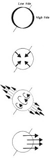 Any
fluid, when constricted, will exhibit a greater thrust. With respect to
tides, two good examples are found in the Bay of Fundy (Nova Scotia) and
the Thames Estuary (London). Here tidal forces are gathered and
amplified due to the particular latitudes and the particular coastal
physical geographies. Here tidal forces are amplified to an extent of
being some 15 to 25 times as high as they are in the open oceanic
locations of lower latitudes.
Any
fluid, when constricted, will exhibit a greater thrust. With respect to
tides, two good examples are found in the Bay of Fundy (Nova Scotia) and
the Thames Estuary (London). Here tidal forces are gathered and
amplified due to the particular latitudes and the particular coastal
physical geographies. Here tidal forces are amplified to an extent of
being some 15 to 25 times as high as they are in the open oceanic
locations of lower latitudes.
The fluid ocean is unconfined; the fluid magma is completely confined. This affects the gathering or concentration of thrust in certain belts or regions. Also the nature of water as a fluid is somewhat different than magma as a fluid. At high temperatures, magma becomes increasingly fluid, and at lower temperatures, it becomes increasingly viscous!
Iron, for instance, at surface temperatures, is brittle. However at higher temperatures, iron becomes as flexible as a leather belt. At yet higher temperatures, in its molten form, it will easily pour. At the high temperatures inside the Earth, magma has a nature which is neither exactly like a fluid, nor exactly like a solid. It is described as "plastic-like." It is something like asphalt, beeswax, honey or molasses. It will flow, but at retarded rates.
Three
major forces acting upon Earth's crust
during the period of celestial
crisis!
An illustration of
the three forces conceived as having been exerted upon the Earth's
magma.
(Figure 5)
|
Bulging or Oblateness
(Figure 5) Force 1 & 2 combine to achieve the Earth's oblateness. |
|
|
Force 1 Earth's gravity |
|
|
Force 2 Earth Centrifugal force; due to rotation |
|
|
Force 3 Visitor's' gravity; the introduced force, which interrupted the equilibrium, previously existing between the first two forces. |
|
| 3 major forces acting upon Earth's crust during the period of celestial crisis! | |
|
Other lesser forces included: a. The gravities of the Sun & Moon! b. The magnetic fields of these four celestial bodies! |
|
Dealing here with the effect of an introduced gravitational force upon the magma, and the reaction of the magma upon the inside of the Earth's crust!
Due to the centrifugal force of a rotating sphere, angular momentum occurs along with the force of gravity. The Earth is an oblate sphere with the polar diameter being some 27 miles shorter than the equatorial diameter. This bulge is due to the speed of the Earth's rotation. The Earth's crust, at the equator rotates a little over 1,000 miles per hour, and the magma directly under it has a similar velocity. All magma in the various regions within the Earth has an angular momentum somewhere between these two extremes of 0 and 1,000 miles per hour depending on location.
The effect of the introduced force was to cause a new oblateness or bulge, of great dimensions. A second effect of the force was an induced drag on the magma in centrifugal rotation. The drag was effected in an arcuate, sweeping pattern on the inside of the Earth's crust.
Thus there were two vitally important but distinct factors,
(1) the amount of the bulge due to the gravitational conflict;
(2) the direction of the bulge and its drag, related to the direction and speed of rotation.
In addition to these factors, it must be kept in mind that the Earth's thin crust or skin is considered to be as flexible as a man's leather belt. It was the give and take between these forces being alternately exerted and released within the Earth's crust upon which the explanation rests. This give and take, or alternating exertion and releasing upon the inside of the Earth's flexible crust explains both
(1) the magnitude of the thrust
(2) the placement of the geographical pattern, a pattern incorporating series after series of arcuate curves which merge into one or the other of two great circle patterns.
With these factors in mind
the fragileness of the Earth,
the minute thickness of its crust,
the vastness of its internal oceans of magma,
the velocity of its rotation,
the flexibility of its crust,
the confinement
the viscosity of the magma
A new oro-graphical theory (mountain building) is about to be set forth, based on the historical probability of astronomical conflict. It reveals the origin of these great orographical systems which span our planet, and form the backbone for several continents!
![]()
2. Approaches To Orogenesis
(Uniformitarian)
During the last 100 years, seven major theories of orogenesis have been propounded. They are listed as follows:
1. Continental Drift
2. Convection Currents of Magma
3. Differential Rotation
4. Oscillations (Undulations)
5. Planetary Contraction (Crustal Shortening)
6. Planetary Expansion
7. Polar Wandering
Several things should be noted regarding these seven theories, and their various methods in endeavoring to handle the problem of an adequate explanation for mountain-building. Note that
(1) all seven theories assume Earth configuration has been a process requiring multiplied millions of continuous years,
(2) forces exerted are confined to originating from within the Earth's crust, and (3) the many kinds of stress need to be explained together or in tandem.
Still among many modern thinking assumptions that mountain uplifts only caused by: (1) a local in scope, (2) ancient in terms of multiplied millions of years, (3)caused exclusively by conditions within the Earth's crust, oceans and atmosphere. This has lead to a serious error! Which has overruled and ignored astral catastrophism as a possible explanation without even revealing reasons of substance for the rejection. Astral catastrophism is a possible and probable explanation of ancient upheavals which resulted in our terrestrial patterns of mountain systems; it explains this and much more!
Considering astral catastrophism will be an initial step,
if not the step, to offering substantial explanation for orogenesis and
the geographical pattern thereof. Society has left it up to the
earth-oriented geologist to determine the prime cause for orogenesis.
3. The Geographical Pattern of Distribution of
Recent Mountain
Uplifts!
Prior to analyzing this subject, it should be recalled that the mountain ranges of the Earth are significantly similar to the pattern of those of the Moon. Both ranges have a series of arc-like curves, although those on the Earth are more elongated. Both ranges contain dendrite patterns. In fact, the mountains of both bodies are also similar in their elevation (although the Moon is about 1/80 of the mass of the Earth and 1/50 of the volume of the Earth). Astronomers have noted this, and have suggested that similar processes were involved in their formation. This should prove to be a good clue, even though the two regions are some 240,000 miles distant!
Mountains might have
been scattered
Recent uplifts
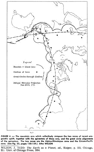
Mountains might have been scattered across the face of the Earth in one or two of many different possible patterns, depending on cause of orogenesis. Among the possible patterns are the following: Figure 6[
1. Equatorial
2. Latitudinal
3. Longitudinal
4. Great Circles
5. Magnetic Equatorial
6. Magnetic Polar
7. Continental Peripheries
8. Continental Centralities
9. Random
10. Sunburst Patterns
11. Ubiquitous Wrinkles
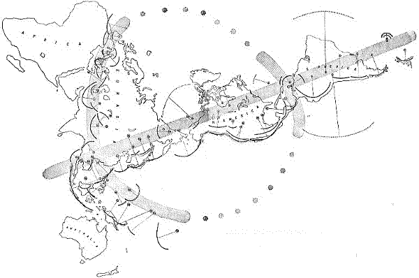
Figure 6 illustrates the mountain arcs of the world on a global basis.
Of these eleven possible patterns, the fourth listed pattern is the pattern of recent mountain uplifts, with a qualification. Mountain arcs occur, spread across the Earth's surface. It is not the mountain arcs, specifically, which occur in great circle patterns. Rather it is the location of the epicenters of the mountain arcs which, when connected in series, presents a great circle lineal pattern. The great circle pattern does not exist once, but rather twice. One system is the Circum-Pacific, and the other is the Alpine-Himalayan. Figure 6 illustrates. (Further research on sub-oceanic mountain systems, currently being described and plotted, may reveal further arcs, curves and great circles.)
1. The mountain systems of the Earth are found in great scallop-like arcs, which in turn merge into greater arcs, which in turn merge into sweeping, planet-traversing circles. Their pattern seemingly is indifferent to either continental massifs or to oceanic basins; they traverse either with equal ease. This is illustrated particularly in the regions of the Western Pacific, with the numerous island chains, which are the tops of submerged mountain arcs.
2. Mountain systems possess dendritic patterns with auxiliary ranges, and spur ranges, separated by valleys and basins. The relationship of the main range to the auxiliary ranges is somewhat like the grain of the stock of a Christmas tree to its branches, and is particularly observable to mountain-climbers with their advantageous, panoramic views.
3. Mountain systems often occur in parallelism--that is to say that major systems are frequently parallel. The Cascades and the Rockies are one example, the Sierra Madre Occidental and Sierra Madre Oriental are another example. The Himalayas and the Kun Luns are a third example. Other examples are too numerous to mention.
The recent uplifts occur in series
The recent uplifts occur in series, in scallop-like arrangements and in great circles. (Figure 6) The great circle alignment is formed by drawing a line through the epicenters of the arcs, often 1,000 miles from the uplift itself, and located amid broad, undulating plains, and not by drawing a line between the mountain ranges themselves. If viewed from our Moon, or man-made satellites, or some other proximate position in space near the Earth, this would appear as a straight line crossing both latitudes and longitudes. This direct alignment suggests that mountain uplifts occurred
(a) on an interrelated basis,
(b) on a global scope.
The Circum-Pacific uplift includes arcs which begin in Antarctica and follow the rim of the Pacific Ocean through the Western Americas, and along the eastern ridges of Asia to Indonesia. This is the so-called "Pacific Rim of Fire." It is a zone of both earthquake activity and volcanic activity, indicating that isostatic adjustments of the Earth's crust in this zone are yet being achieved; the same applies to the Alpine-Himalayan cycle. This is indicative of recentness!
In our hypothesis herein set forth, a series of line diagrams is given, which illustrates a possible model--an astronomical model--for the cause of the global catastrophe. The 'astral intruder' is shown in relation to the solar system, the Earth and the Moon.It is also shown with respect to the Earth's magnetic field.
Any adequate theory of orogenesis must explain the alignment of mountain systems, traversing the face of the Earth. It should also explain the similarity to the lunar mountains. But in addition, it must be able to account specifically for many kinds or types of stresses which obviously have been involved, and not just one or two kinds. This includes many types of vertical movements and horizontal movements. This also includes several kinds of formations.
Logically the approaching gravitational force caused a new bulge upon the Earth's surface, due to the magnitude of the new gravitational field. The new gravity exerted a pulling or lifting force upon the rotating magma, but also exerted a drag on the velocity of the magma as it centrifugally rotated around the Earth's axis.
There were new pressures caused by the tides of magma, pressures which required new adjustments and new releases. Among the new adjustments were welts or wrinkles or uplifts upon the Earth's thin skin, uplifts including both igneous and sedimentary rock alike, and in arcuate or scallop-like alignments. Another adjustment was the release of pressure by the bleeding of lava (magma) out upon the Earth's crust, forming basaltic plateaus and volcanic cones. The surging, throbbing, pulsating magma, rising to two mighty crescendoes each day, tortured the inside of the Earth's skin with a bellows-like periodicity.
The stresses must have been tremendous from the inside of the Earth; simultaneously the face of the Earth was washed twice every 24l/2hours by continental tides. In addition rain (intense rain--Genesis 7:12) also occurred, further rinsing the Earth's face. Under these conditions, if water compression on the Earth's surface at "sea level" resulted in pressures exceeding two tons per square inch, pressures perhaps 100 to 10,000 times greater occurred from within. The Earth's crust was thus tortured from within and without simultaneously.
The formation of arcuate uplifts may be accounted for in terms of the rotation of our sphere simultaneously with tidal movements of the magma. It is noticed that many of the mountain systems in the Alpine-Himalayan and Circum-Pacific Belts are parallel. The astral intruder interacted with the Earth, and revolved around the Earth in a binary manner for some 8 months, and was drawn out beyond the Earth-Moon system by the Sun. This then lays the basis for explaining the repeated parallel ranges of orogenetic uplift on a rotating planet, along with parallel and offsetting crustal trenches. Their great circle geographical pattern merely reflects the astrophysical (gravitational) nature of their cause.
Similarly, it assists in explaining the many repeated layers of alluvium, repeatedly laid down and compressed in sharply separated series, forming vertical sequences. In this way, two types of vertical movements are simultaneously explained.
(1) the vertical up-thrust or magma, forming mountain ranges,
(2) the vertical and successively layered strata, resulting from tidal deposition.
Both vertical movements include shifts of fluid, namely:
(a) tidal magma,
(b) tidal water, both shifting in oceanic volumes.
Both are explained as responses to the same gravitational interaction; both are explained as simultaneous; both parallel geological observations; both parallel elementary astrophysical principles! Vertical movements are thus explained!
Horizontal relationships across the Earth's surface also must be recognized! The realization is that the Earth was in constant rotation, and the bulge zone (both facing toward and facing opposite the visitor) constantly shifted within the same zone of uplift. This principle assists in understanding the very apparent and very consistent horizontal parallelism of mountain ranges.
Illustrations of mountains uplift on Earth's surface!
Figure 7-12
Ç Figure 7 illustrates Western North America from Alaska to Mexico. Here occur differing types and heights of mountain curves. Some are primary and some are secondary; some are sedimentary and some are volcanic. Offsetting trenches are also found, parallel to the mountain arcs.
 Figure
6
illustrates the mountain arcs of the world on a global basis. Figures 7
through 11 illustrate the mountain arcs of the world, region by region
and continent by continent. They reflect recurring patterns around the
world. Figure 12 then further illustrates these arcs on a sub-regional
scale.
Figure
6
illustrates the mountain arcs of the world on a global basis. Figures 7
through 11 illustrate the mountain arcs of the world, region by region
and continent by continent. They reflect recurring patterns around the
world. Figure 12 then further illustrates these arcs on a sub-regional
scale.
Figure 7 illustrates Western North America from Alaska to Mexico. Here occur differing types and heights of mountain curves. Some are primary and some are secondary; some are sedimentary and some are volcanic. Offsetting trenches are also found, parallel to the mountain arcs.
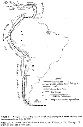
Figure 8 [ illustrates South American mountain arcs. The same kinds of uplifts again occur. However here is a further illustration of a reverse arc (the Caribbean region), similar to the reverse arc of the South Sandwich Islands (Fig. 6).
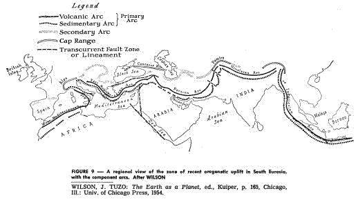
Figure 9 gives this arc-like alignment in Southern Eurasia. This area includes the "roof of the world," the Himalayan group, with their associated ranges. It also includes the Ararat-Cauca-sus-Elburz group, where the Ark was grounded, according to the Genesis account.
Figure 10 gives this arc-like alignment for Melanesia, an area mostly inundated with water. In this region, some of the deepest trenches of the Earth's crust are found, and they too are associated with mountain uplifts, with which they are parallel.
Figure 11 illustrates the great, sweeping mountain arcs for East Asia.
Figure 12, the echelon structures of the East Asian Arcs, illustrates these same trends as seen on a sub-regional scale.
 Z
Figure 9
gives this arc-like alignment in Southern Eurasia. This area includes
the "roof of the world," the Himalayan group, with their associated
ranges. It also includes the Ararat-Cauca-sus-Elburz group, where the
Ark was grounded, according to the Genesis account.
Z
Figure 9
gives this arc-like alignment in Southern Eurasia. This area includes
the "roof of the world," the Himalayan group, with their associated
ranges. It also includes the Ararat-Cauca-sus-Elburz group, where the
Ark was grounded, according to the Genesis account.
Thus it is demonstrated that mountains are not dispersed in a random pattern over the surface of the Earth. They are strung out; something like the way a string of lights is hung around a Christmas tree, hanging from branch to branch, in arcuate curves. The entire pattern is suggestive of counter-dominating gravities, viscous, fluid magmas, and a rotating sphere. If tidal mechanisms uplifted the mountain systems of the Earth as well as the oceans at the time of the Flood, then the geography of both hemispheres has been drastically reorganized by this celestial event.
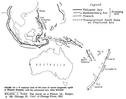 Figure
10
[
gives this arc-like alignment for Melanesia, an area mostly inundated
with water. In this region, some of the deepest trenches of the Earth's
crust are found, and they too are associated with mountain uplifts, with
which they are parallel.
Figure
10
[
gives this arc-like alignment for Melanesia, an area mostly inundated
with water. In this region, some of the deepest trenches of the Earth's
crust are found, and they too are associated with mountain uplifts, with
which they are parallel.
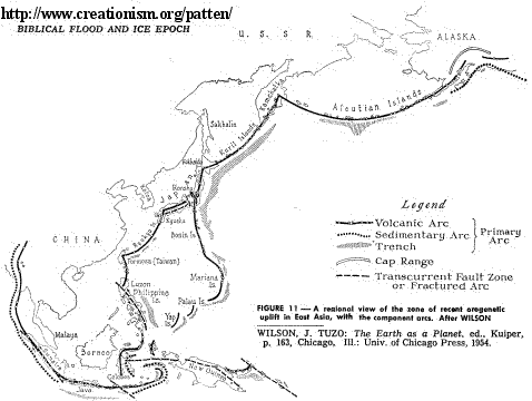 Figure
11
illustrates the great, sweeping mountain arcs for East Asia. Figure 12,
the echelon structures of the East Asian Arcs, illustrates these same
trends as seen on a sub-regional scale.
Figure
11
illustrates the great, sweeping mountain arcs for East Asia. Figure 12,
the echelon structures of the East Asian Arcs, illustrates these same
trends as seen on a sub-regional scale.
4. The Lunar
Mountains
Figure 12
È
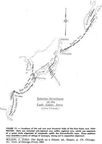 Figure 12,
the echelon
structures of the East Asian Arcs, illustrates these same trends as seen
on a sub-regional scale.
Figure 12,
the echelon
structures of the East Asian Arcs, illustrates these same trends as seen
on a sub-regional scale.
In
addition to being similar in pattern to those great ranges of the Earth,
the mountain ranges of the Moon also rise to similar elevations. Our
Rockies rise to 15,000 feet, as do the Sierras, Alps, and Owen-Stanley
Range, among others. The Andes rise to 23,000 feet, as do the Hindu
Kush, the Tien Shan and the Kun Lun ranges. The mighty Himalayas, with
their sawtooth faces, rise to 25,000 and 26,000 feet, with one peak at
29,000 feet. On the Moon, the Lunar Apennines have been estimated at
20,000 feet above the mountain floor. The Leibnitz and Doerfel ranges
are estimated at 26,000 feet. One peak in the Riphaen Range is estimated
at nearly 30,000 feet.
At the very least, the similarity of the pattern of mountain ranges, plus the similarity in their elevations, suggest a similar kind of orogenesis with the mountain systems of the Earth. The assumption has been that the Moon was more solid and less plastic-like in its internal structure than the Earth. This has recently been questioned, due to the report of some observed volcanic activity. Perhaps the Moon, like its Binary Partner, is also composed of much fluid magma. If so, the possibility is that the Moon's mountain-building processes may be similar with those of the Earth; they also may be simultaneous in timing. With all of these aforementioned features considered conjointly the whole picture becomes historically more credible (and scientifically more apparent).
5. Qualifications for a Theory of Orogenesis
Any
understanding of the forces which have sculptured our fluid sphere must
accommodate many qualifications, not few. Some of the qualifications are
major; others are minor; all are significant. Those qualifications which
are major to some will be minor to others, and those minor to some will
be major to others, depending on their backgrounds and disciplines.
However, all the qualifications, not just some, must be adequately met
in order to propose an adequate and helpful theory on orogenesis.
To sum up, it is almost inevitable to admit that the physiographic evidence regarding features on the Earth's surface is such that it must be assumed that some parts of the Earth's crust have been subject to compression (crustal shortening), others have been subject to tension (mid-ocean rifts) and yet others to shearing (fracture zones). Most theories have been proposed for the purpose of explaining only one of these features and are therefore inadequate with regard to the others. A theory of orogenesis, to be acceptable, must be flexible enough to allow for compression, tension, and shear of sufficient magnitude to be produced in the Earth's crust. It appears, therefore, that the problem of finding the causes of the various geodynamic features must be regarded as still unsolved.
List of 14 specific qualifications for an adequate theory of orogenesis
The following is a list of 14 specific qualifications for an adequate theory of orogenesis; four are considered as major or overriding in importance, while the importance of the other ten qualifications is not to be deemphasized. Major considerations for orogenesis include explanations for:
Four major specific qualifications (overriding in importance)!
1. Correct scope
2. Correct timing
3. Correct distance of causation
4. Correct direction of causation
*These four overriding specifications are developed further in the succeeding pages of this chapter.Other specifications, not developed further, include:
5. The Great Circle Pattern (and epicenters of the arcs).
6. The Scallop-like Alignment.
7. Parallelism of Uplifts.
8. Parallelism of Trenches with Uplifts.
9. A Mechanism for Sudden Thrust.
10. A Mechanism for Uplifting Thrust.
11. A Mechanism for Sufficient Magnitude of Thrust.
12. A Mechanism Including Numerous Types of Stress (not just one or two).
13. A Simultaneous Mechanism for Uplifting Oceans of Magma and Water.
14. A Simultaneous Mechanism for Forming Both Igneous and Sedimentary Formations.
It is therefore necessary to re-examine all theories of orogenesis that have ever been invented, in order to determine what can be saved of them in the light of the presently available facts. If this is done, it becomes immediately obvious that something fundamental is wrong with each and every one of the theories.
In the theory of astral catastrophism, most (and indeed the author thinks all) of these clear specifications are adequately answered. Certainly the specifications involving parallelism are apparent. Certainly the mechanisms involving force are met. Certainly the features of simultaneous magma and watery tidal upheaval are inherent. Incidentally (but not coincidentally) the genesis of the lunar formations are also in focus.
The astral visitor was involved with the Earth-Moon system for several months!
 In
this theory of astral catastrophism, it is conceived that the astral
visitor was involved with the Earth-Moon system for several months; it
did not graze the Earth just temporarily. It perhaps revolved around the
Earth twice, bringing repeated crescendoes and diminuendos to the
Earth's surface as it rotated in chaos. As
Job
suggested, the "pillars
of the Earth trembled."
With each approach, a new zone of horizontal uplift occurred (the
Circum-Pacific first; the Alpine-Himalayan second). And with each
rotation during crisis, there occurred a new range of horizontal uplift,
or a further movement of a prior uplift. Series after series of sediment
was simultaneously deposited and/or compressed.
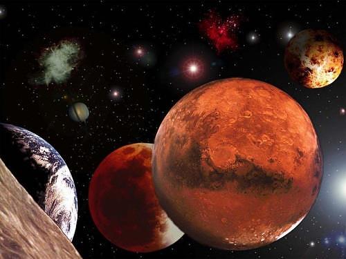
(Picture Source: Nasa;
Planet
Earth from
planet Mars'
view!)
In
this theory of astral catastrophism, it is conceived that the astral
visitor was involved with the Earth-Moon system for several months; it
did not graze the Earth just temporarily. It perhaps revolved around the
Earth twice, bringing repeated crescendoes and diminuendos to the
Earth's surface as it rotated in chaos. As
Job
suggested, the "pillars
of the Earth trembled."
With each approach, a new zone of horizontal uplift occurred (the
Circum-Pacific first; the Alpine-Himalayan second). And with each
rotation during crisis, there occurred a new range of horizontal uplift,
or a further movement of a prior uplift. Series after series of sediment
was simultaneously deposited and/or compressed.
(Picture Source: Nasa;
Planet
Earth from
planet Mars'
view!)
Thus in the view of astral catastrophism, one section of the Alps may have been uplifted one day; another section may have been uplifted a few days or even weeks later. But the time lapse was measured in hours, days and weeks, and not in terms of millions, tens and hundreds of millions of Lyellian years!
Correct
Scope.
This catastrophist considers the Alps to have been raised up suddenly,
and with great force, along with the rest of the Alpine-Himalayan and
Circum-Pacific series. This was a global uplift, involving both tides of
magma and the lesser but yet very considerable inundation of watery
tides. Thus the Jura Alps, along with the marine and terrestrial
fossil-bearing strata contained therein, were uplifted! The Alps
collectively occupy less than .01% of the Earth's surface!
|
How, when, the Earth's surface was affected!
|
|
|
This catastrophist consideration |
That all (100%) of the Earth's surface was affected, one way or another. In terms of scope, there is a difference between the two approaches, and the magnitude of this difference may be of equal value as to noting the basic difference itself. Catastrophism considers that 100% of the Earth's surface was affected in the crisis year! |
|
Correct Timing. |
The author's dating of this orogenetic uplift and associated Flood is 2800 B.C., + or - 500 years. This is approximately 5,000 years ago! |
|
Distance of Causation. |
In the catastrophic approach, distance was somewhere between 25,000 and 250,000 miles out in space at various stages. |
|
Direction of Causation. |
Catastrophism considers the cause to be celestial, straight up. The variance verges on 180°, which is the greatest possible difference! |
|
Catastrophism: |
The doctrine that changes in the earth's crust have generally been effected suddenly by physical forces. Catastrophes have been primarily responsible for the remarkable engraving and etching of our Earth's surface; the same is true with the surface of our scar-faced satellite. This study about the Flood-Catastrophism proposes that this remarkable sculpturing of our terrestrial home has occurred as a result of astral catastrophes, with regard to causation, direction, scope, distance and timing! |
6. A Convergence of Disciplines
This is the second of three chapters dealing with catastrophism and the Earth's three fluid components 1.hydrosphere, 2. lithosphere 3. atmosphere. The approach of astral catastrophism cuts across lines of many disciplines, from one horizon almost to the other. It begins with the physical sciences and basic astral premises. The conflict which occurred produced conditions, effects and patterns which were vital to the re-establishment of biological life, and hence to the natural sciences.
Effects of thinking in the natural sciences have come to have immense effects in the social sciences. Among the many disciplines which are involved in this approach are astronomy, astrophysics, ancient literature, climatology, geography, geology, history, folklores and anthologies, anthropology, zoogeography and historical ethnology (survival patterns).
The catastrophic theory as contained herein, will attempt to answer some questions, and it will perhaps give rise to many more! The catastrophic theory will no doubt give rise to controversy in the geological profession. The catastrophic theory as presented is not offered as being in any sense anti-geological; rather it presents to geology some new and exciting horizons to traverse, after it arises out of its comfortable of thinking! (anti-spiritual & anti-scientific)
Could it be that the Ice Epoch was part and parcel of this same catastrophe?
Tides, whether of oceans or magma, are a response to a gravitational interaction of two or more fields of gravity. The Flood and the orogenetic upheaval were different phases of the counter-dominating gravities.
However, in addition to the field of gravity, the Earth also possesses a magnetic field. The magnetic field would be in counter-dominating interaction with the magnetic field of the visitor. The Ice Epoch, it is posited, was primarily related to the magnetic phase of this cataclysm. Could it be that the Ice Epoch was part and parcel of this same catastrophe? Could it be that the Flood and the Ice Epoch were simultaneous in their enveloping of the Earth?
It
took the waters many weeks, and even months,
to drain off!
Following the Flood catastrophe, new equilibriums were reached. It took the waters many weeks, and even months, to drain off. The zones of mountain uplift continued quaking for years and decades, even centuries, as a new isostatic equilibrium gradually was established. It took centuries for the ice masses to outflow and melt. And as the ice masses melted, they fed icy cold water into the oceans, keeping the oceans at an abnormally low temperature. And it took dozens of centuries for the oceans to gradually find a new equilibrium of temperature.
It was in this earlier postdiluvian period, when ice was out-flowing over the Flood stratigraphical, that geological ice scourings were achieved. And it was in the early postdiluvian period that the oceans, and the Earth's wind systems were much lower in temperature than they are now. This, then, was a cool, even a cold era, and it continued until new hydrographical and climatic equilibriums were gradually reached.
Nevertheless, the origin of the mountain uplifts, the Flood, and the Ice Epoch were simultaneous and celestial. It is to this second and equally important phase of the catastrophe, the glacial phase, to which in: "The Cause of the Ice Epoch" (6) is directed.
About the author Donald W. Patten & his scientifically written book!

Donald W. Patten, a geographer by training and lifelong interest, was born on November 11, 1929, in Conrad, a small town on the high plains of Montana near Glacier National Park. He entered the University of Montana in 1947 and engaged upon a series of studies including ancient history, ancient literature, climatology, genetics, geography, geomorphology, mathematics and philosophy.
While absorbing humanistic viewpoints, he also began to read the Bible, and to reflect upon its claims. In 1948, he experienced conversion to Biblical Christianity, and through a coincidence, was given pulpit duties as a student at a small, rural community church in the village of Lolo. Following his conversion, this further experience in lay preaching and teaching was a most profound influence in his young manhood, coming in the midst of his studies.
Mr. Patten received a B.A, in Geography from the University of Washington in 1951, and an M.A. in Geography in 1962. Mr. Patten and his wife Lorraine have one daughter and six sons.
The biblical flood and ice epoch was conceived in 1960, and has been generated by his interests in various fields of geography, history and science.
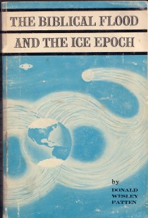
The Biblical Flood & The Ice Epoch
 The author contends that, through the agency of astral
principles, the Earth became engaged, or engulfed, in simultaneous
gravitational upheavals and magnetic conflicts. There came with
suddenness to our fragile, spiraling sphere, THE BIBLICAL FLOOD AND THE
ICE EPOCH. Readers of this unique book will find a challenging and
refreshing view of ancient catastrophism and its conclusion, Divine
Creation, a subject of importance in this age of increasing intellectual
rootlessness.
The author contends that, through the agency of astral
principles, the Earth became engaged, or engulfed, in simultaneous
gravitational upheavals and magnetic conflicts. There came with
suddenness to our fragile, spiraling sphere, THE BIBLICAL FLOOD AND THE
ICE EPOCH. Readers of this unique book will find a challenging and
refreshing view of ancient catastrophism and its conclusion, Divine
Creation, a subject of importance in this age of increasing intellectual
rootlessness.
It is over and against the prevailing monopoly of uniformitarian thought (which proposes that oceans of time are necessary for anything and everything, both geologically and biologically) that Mr. Patten proposes his view of historical celestial crises, global catastrophes. Such catastrophes may explain many features about several planets. Such catastrophes, relative to the Earth-Moon system, explain the raising up of mountain ranges, sweeping across the face of the Earth in arcuate alignment, similar to the mountain patterns of the Moon.
This was achieved suddenly, and by tidal upheavals within
the oceans (of centrifugally rotating lava) within the Earth's crust.
Simultaneously, tidal upheavals engulfing the oceans raised tides of
subcontinental dimensions on the Earth's crust, thus the historically
recorded Deluge, or Flood.
13540 39th Avenue N.E., Seattle, WA. 98125 USA
Biblical Scientifically studies are always freely available for everyone!
There are several Scientifically organizations involved who gave their permission & their devotion to add their information about this subject on this site; to serve the Lord and to serve you as well! See at list below this site! As editor; Paul van Beek; I really appreciate the author Donald W. Patten & his daughter Judy Fenton for their cooperation to make this site to a reality!
This ministry Scientifically - Teaching’s web site, with many of Biblical Scientifically studies is always freely available for everyone! It is written on series of “Neutral Site’s"! As such, these detailed teaching’s site’s cost a lot of precious time and financial commitment for the authors and the publisher as well! Every study, that takes you for this specific site a few hours scientifically study-material to read, and the pictures according the story, takes many, many hours of work to write, to edit, to design, to modify, to format and technically make available & maintain on the web server! That is the simple reality of the situation!...Paul van Beek See also at: Graphic Design
This "Teaching & Information in the form of a Neutral" site of “Science of Noah' Flood - Gravities” is created

 The biblical flood and ice epoch was conceived in 1960, and has been
generated by his interests in various fields of geography, history and
science.
The biblical flood and ice epoch was conceived in 1960, and has been
generated by his interests in various fields of geography, history and
science.
With permission (13 May 2008) and cooperation by:
by Donald W. Patten ©; Copyright 1964,
Judy Fenton (Daughter)
Seattle, WA 98125 USA
Bible
verses out of the Dake's annotated Reference Bible (KGV) + Note's
Jewish Bible;
Hebrew Scriptures
Edited; Lay-Out & Graphic designed
by:
Paulus van Beek
![]() God’s
Outreach Ministry Int.
Inc. ©
God’s
Outreach Ministry Int.
Inc. ©
@
E-mail to the Editor/Web-designer for information
Contact
us
for
information to the Editor/Web-designer
P. O. Box 93404; Lakeland; Florida; 33804-3404
'
(863) 660-2444
www.Godsoutreachministryint.org
www.Riverofjordan.org
www.Prophetoffice.org
With permission
is this written, please respect the copy-right of the author!
